

Author: Yuanhao Li.
Nowadays spaceborne data from several altimeters (e.g., from Jason-1/2, Cryosat, etc.) can already resolve oceanographic phenomena with sizes in the order of 100 km. However, we cannot observe very well the submeso-scale oceanic features which may derive from smaller-scale eddies and currents. In this view, the observation of the oceanic submeso-scale is one of the major challenges in ocean observation.
Theoretically, launching more altimeter satellites can help to improve the spatial sampling. However, the very high cost of single traditional altimeter systems will inhibit realization of such a constellation. The goal can more effectively be achieved by using cubesat altimeter constellations. Due to the small size, lightweight and cheap platform components, the total cost (including launch) of a series of cubesat altimeters can be comparable or less than the cost of one large satellite. Due to the advantages of the constellation, the cubesat constellation has the capability to increase the spatial sampling rate and even shorten the revisit time for the target regions. Figure 1 shows our performance comparison result between a single satellite and a cubesat constellation. We input the reference sea level anomaly data from Copernicus Climate Change Service. If there is only one altimeter satellite, many small-scale features in the ocean are invisible (center column). Although some relatively large structures can be seen, many details are missing as well. In contrast, when we have a five satellite cubesat constellation, we can well recover some details of the small-scale structures in the ocean. The black marked frames in the lower row in figure 1 clearly show the improvement.
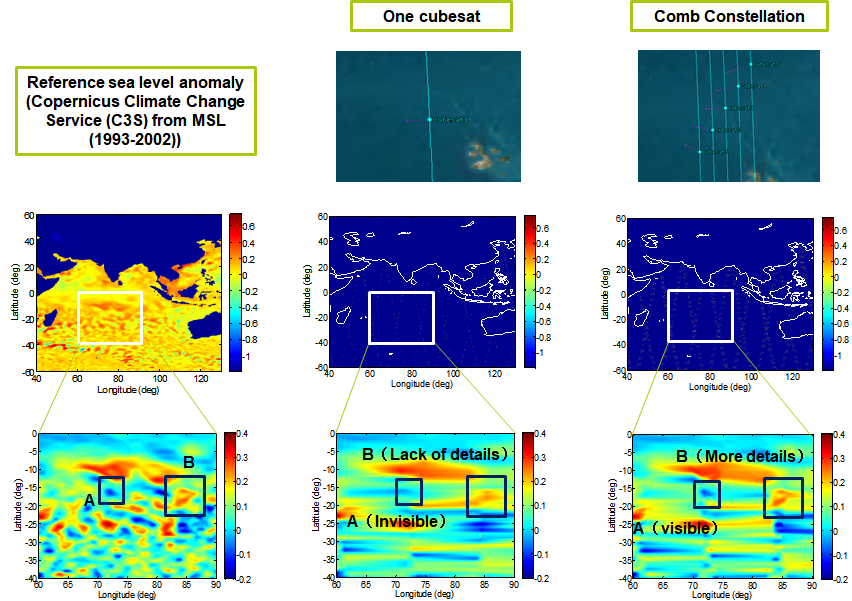
Figure 1: Observation performance comparison between one satellite and a cubesat constellation (five identical cubesats in a non-sunsynchronous orbit; their cross-track distance is 50 km and a 10 s separation in along-track to avoid collisions).